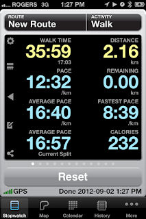
So this past weekend, I neither found any letterboxes nor planted any letterboxes. I did, however, do quite a bit of hiking in some beautiful unexplored-by-me areas of my hometown. The reason I was doing this exploring was to get some scouting done for letterbox placements for the upcoming Box ON plantathon that I will be undertaking, but I had a wonderful day out nonetheless.
 |
| Tracking me while I walked. |
The area I was investigating is actually a park with trails that have either been created or historically used, but are not marked on any map I can find. Because of how the park is shaped and how densely forested it is, it's hard to know where the trails are going - even as you're walking them - and where they might pop you out at the end.
And so, one of the apps that I've taken to using when trekking along these unmarked trails is Cyclemeter - although there are lots of other apps that will do the same thing. Ostensibly, the app is meant to track your cycling so that you can determine distance, altitude change, calories burned, etc, and this app is also set up to track your walks as well. However, I find mine much more useful for my letterboxing trails. I have mine set so that after my tracked hike, it emails me a Google Maps link with the GPS tracked path I took, along with the speed, speed, calories, etc.
So as I went out on this walk to try to find letterbox planting spots, I was able to come home to a mapped trail that I could potentially use to make clues. I also found out today that if I switch to one of my cinemagraph apps, it stops the GPS tracking and I lose some of the data. Lesson learned.
For your viewing pleasure, you can see my trail here. Where it says my start, it is not actually my start - I started at the place marked end because that's where I parked my car. If you look at my walk time, it was actually a lot longer than that because I found a beautiful sitting spot by the Rouge River where I stopped to take a carving break.
If I wanted to do the same path again, I could name the route in the program and see if I could beat my time. Pretty nifty program; I used it a lot about a year ago to time myself and check my speeds while I was commuting by bike into Hamilton from Burlington. Now that I'm not doing that anymore, I found out that you can actually change the default activity (this was meant specifically for cycling) and in this case changed it to walking. Crazy. It would be great for plotting out a map... hint, hint.
As I said, I did pause for quite a while when I found this beautiful spot - I felt completely alone, almost surrounded by water and its bubbly sounds. I had brought carving stuff with me in my bag for some later carving, but decided that one of the only places I had never carved before was on the trail, so I sat down and set up shop.
 |
| On the way to the perfect carving spot. |
I've got a picture of some of the carve that I did down by the water that day. I didn't list this post as a spoiler, mostly because the folks that read this are unlikely to be out to Saskatchewan to find this box anyhow... although, to be fair, perhaps this will entice you to do just that!
Anyways, off to get some more Box ON work done... Happy trails!
 |
| Carving in my carving spot... |
 |
| The perfect carving spot. |


No comments:
Post a Comment